

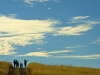
Points of Interest Shady Canyon
Shady Canyon Bonita Canyon Dr. and Shady Canyon Dr., Irvine, CA 92603 Length: 4 miles Trail end points: Juanita Moe Trail at Sand Canyon Ave. and Quail Hill Pkwy. and Bonita Canyon Trail at Bonita Cany...
Quail Hill 34 Shady Canyon Dr, Irvine, CA 92603 (714) 508-4757 The 2.8-acre Quail Hill Trailhead provides a great location to connect to southern Irvine’s extensive trail network. The trailhead i...
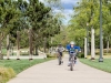
Points of Interest Jeffrey Open Space Trail: An Urban Connection
Jeffrey Open Space Trail: An Urban Connection Families, bikes, dogs, and joggers flock to the Jeffrey Open Space Trail for outdoor exercise and fun. This 2 1/2 mile urban trail parallels Jeffrey Road a...
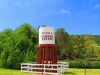
Points of Interest Bommer Canyon
Bommer Canyon 1 Bommer Canyon Rd, Irvine, CA 92603 (949) 724-6738
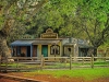
Points of Interest Irvine Regional Park
Irvine Regional Park 1 Irvine Park Rd, Orange, CA 92862 (714) 744-7272